Tuesday 14 September 2021
After pancakes, we headed out to see Cimmaron Canyon State Park. But for reasons unknown, my google maps app decided that I-25 was not contiguous through the northern part of new Mexico, and it insisted we detour off on US-84 far to the east, then circle back. It made no sense, but I believed it. (I even tried putting a point on the route to force it to take the shorter way, but that added 45 minutes to the trip.)
Well, it was wrong. In a lucky way, though. As we were headed aimlessly due east on 84, passing private, ranch roads that Google kept telling us to turn off on, I noticed a sign for Capulin Volcano National Monument, 20 miles. I looked up people's reviews and they were good--you could drive your car all the way to the top of the extinct volcano. So what the heck, we did.
It was indeed too cool for words, however, if I had not been able to get in for free with my Lifetime Senior Access Pass then I probably wouldn't have thought it worth the $20 entrance fee. But it was free and we loved it.
some pictures from the top
Looking down from the rim
The drive to the top, hugging the edge of a narrow, two-lane road with no guard rail until you got very near the top, was scary. I opened my eyes a couple of times to look down, but they didn't stay open very long. But when we were safely at the top, standing on our own two feet on very solid ground, it was a fantastic view.
Back on the highway, I ignored google maps and just stayed on 84 West, and after a long drive through short-grass prairie sprinkled with cholla, we passed through the town of Cimarron and started climbing into the canyon.
The campgrounds were nice, but tiny and not in the really cool part of the canyon. The canyon walls themself were tremendous. The river ran noisily alongside the road, and now that I think of it, it might have been a great place to camp where wildlife were narrowed into a space alongside the water. No matter. It was out of the question--they didn't accommodate RVs as large as ours. According to the reservations page, it was for small trailers only.
Pronghorn antelope!
We returned by about 3:50, so I loaded my camera in the backpack and took Molly's leash. I was determined to see some birds before the trip was over.
Off we went, up a hiking trail. Actually we were on the campground spur to get to the hiking trail, a one-mile self-guided loop. The campground spur to the loop and the first part of it were rugged and did a lot of climbing. we saw a couple of really cool birds at first, but they evaded my lenses.
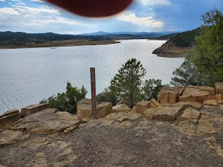
Lake Trinidad
The loop trail was numbered, 1-15 or so. We got up to number 10 when I really wanted to quit--a thunderstorm was looming to the north. I pulled up the trail map on my phone and confirmed that it really was a circle, and only a 1-mile circle. We'd already been walking for about thirty minutes, so most likely we were near the end. And we were.
We returned, birdless, about a half hour before the rains came.


No comments:
Post a Comment